Atlanta Beltline, Inc. Announces Next Steps for Northwest Corridor
Planning and design for northwest segment is key step to closing the 22-mile loop Atlanta – Atlanta Beltline, Inc. (ABI) published a Request for
- Design & Construction
- Atlanta Beltline‚ Inc.
Planning and design for northwest segment is key step to closing the 22-mile loop

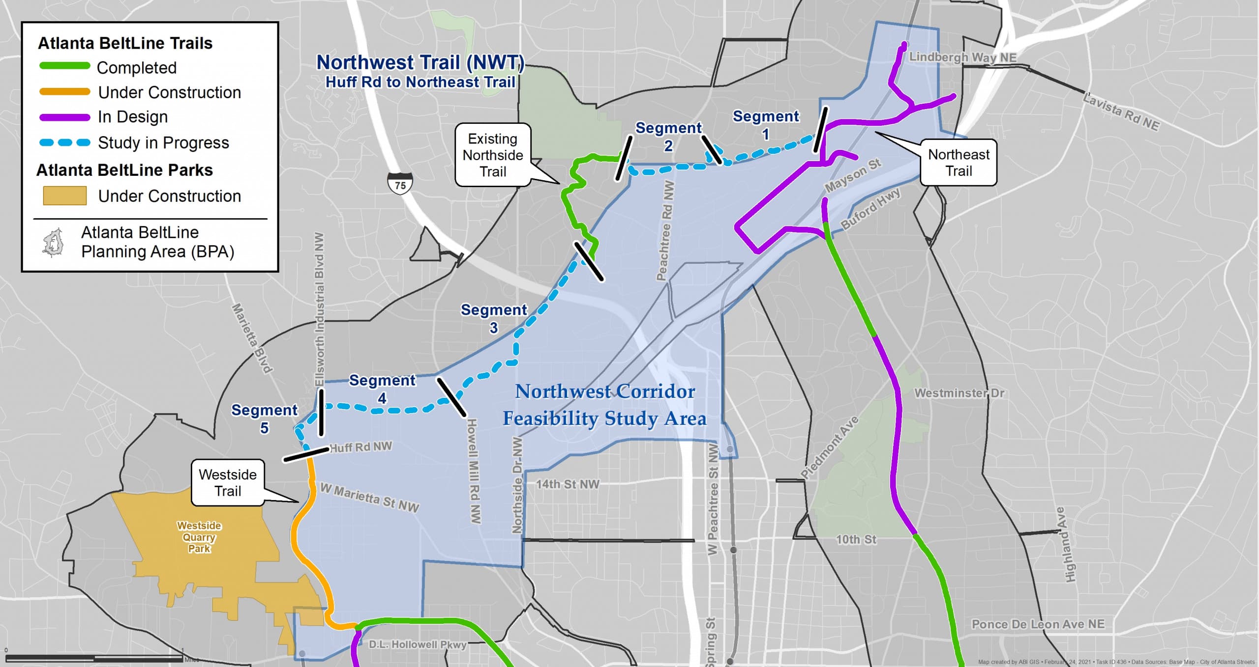
Atlanta Beltline Northwest Trail and corridor feasibility study area map
Atlanta – Atlanta Beltline, Inc. (ABI) published a Request for Statements of Qualifications today for the Northwest Trail Feasibility Study. This 4.4-mile segment will run from Huff Road on the westside to the Northeast Trail at Peachtree Creek in southern Buckhead. ABI is seeking an engineering consultant to study multi-use trail alignments through this northwest quadrant of the Beltline loop. ABI will a release a separate Request for Qualifications this spring to commission a feasibility study for transit. The selected consultants will work together seamlessly to define both trail and transit alignments.
The northwest segment presents unique challenges due to existing active freight rail lines, which may not be feasible options for trail or transit alignment. ABI is coordinating with both CSX and Norfolk Southern Railroad and will collaboratively investigate multiple possibilities, to include sections where trail and transit run side-by-side and others where they run separately. As the alignment study progresses, the Beltline trail alignment may be aligned outside of the active freight rail corridors.
ABI will be investigating creative alternatives to assemble the real estate for this corridor. The work will likely include repurposing existing road and sidewalk infrastructure, using land adjacent to water ways, and actively working with property owners in this region.
The northwest corridor also presents exciting opportunities for connections to existing and planned regional trail infrastructure, including the Atlanta Beltline’s Northside Trail by Tanyard Creek and the future termini of the Northeast and Westside Trails; PATH Foundation trails (PATH 400, Silver Comet Trail, and Westside Beltline Connector); and Westside Park.
The Northwest Trail Feasibility Study will be funded utilizing local TAD funding.
In January, Atlanta City Council proposed legislation that would create a Special Service District (SSD) to fund completion of the Atlanta Beltline’s 22-mile multi-use trail loop. If approved, the funding would provide a critical $128 million for the northwest corridor, representing 36% of the SSD’s projected $350 million. The northwest corridor budget includes alignment / scoping studies, engineering, the purchase of real estate and real estate easements, utility relocation, and construction.
Without additional funding from the SSD or another innovative funding source, the trail loop will likely not be delivered by 2030 and would not spur the expected affordable housing, economic development, job creation, and connectivity outlined in the Beltline vision. More information is available at www.beltline.org/ssd.
Interested applications can view the Request for Statements of Qualifications for the Northwest Trail Feasibility Study and all open procurements online at www.beltline.org/procurement. ABI will post additional information about the northwest corridor as it becomes available and all public meetings on the topic will be posted on www.beltline.org/meetings.
Subscribe to In The Loop, our monthly newsletter, for Beltline news, events, announcements and more.