Northwest Trail Feasibility Study Report and Results Announced in Public Community Meeting
Northwest Trail Feasibility Study Report and Results Announced in Public Community Meeting Two prioritized corridors will move into design with fur...
- Parks & Trails
Northwest Trail Feasibility Study Report and Results Announced in Public Community Meeting
Two prioritized corridors will move into design with further study to take place on three corridors

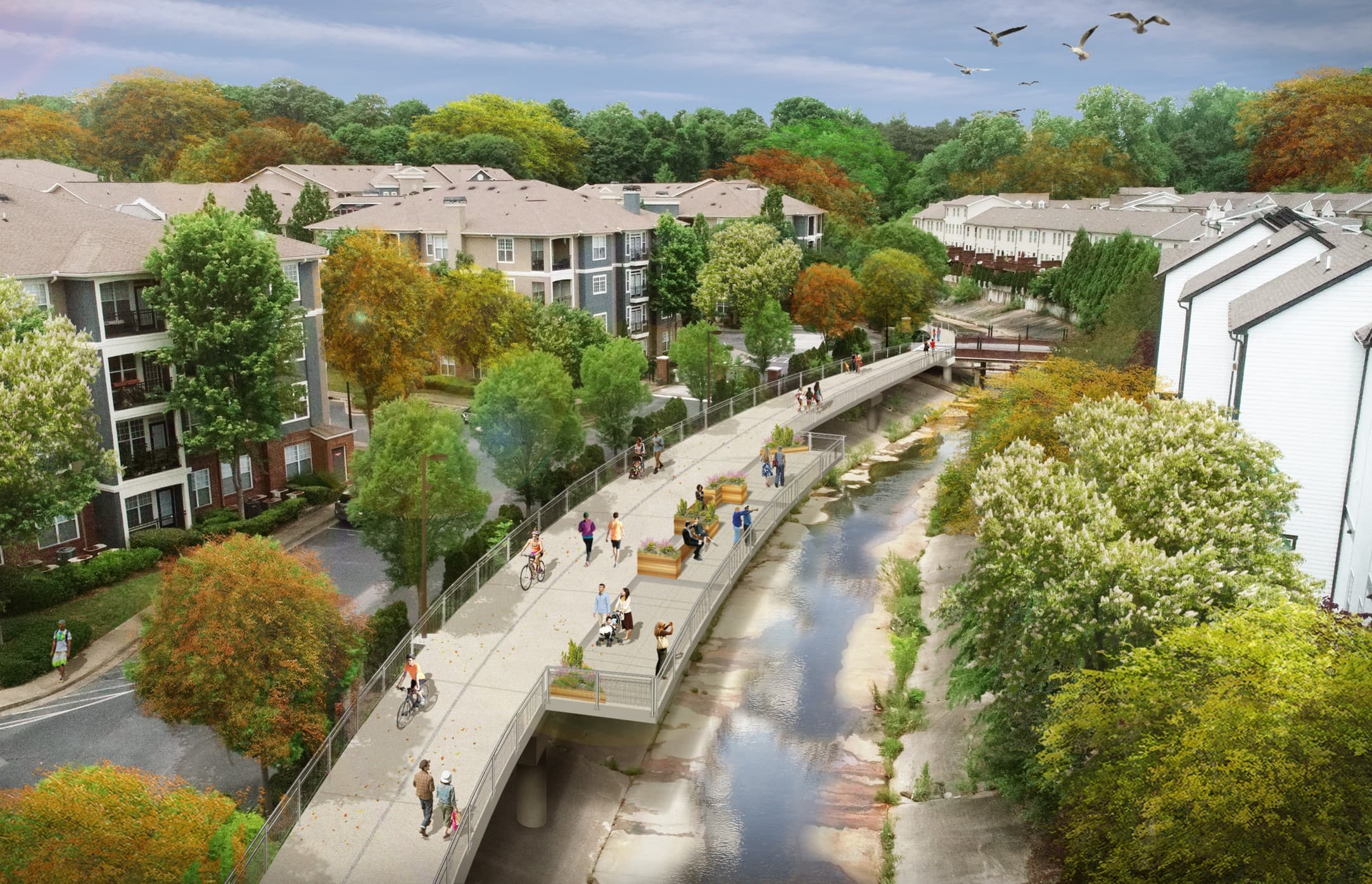
Northwest Trail proposed rendering along a channel leading to Tanyard Creek.
Atlanta Beltline, Inc. (ABI) and PATH Foundation held a joint public meeting this evening to present the results of the Atlanta Beltline Northwest Trail Feasibility Study. The two organizations presented the prioritized trail alignments for the majority of the corridor and determined that a portion of the three eastern alignments requires further study.
The original vision for the Atlanta Beltline trail depended on acquiring abandoned and under-utilized rail corridors that formed three-quarters of a circle around the urban core of Atlanta. The northwest quadrant of the Beltline has no such abandoned rail corridor available. Land will need to be acquired and negotiated in order to complete the 22-mile loop. This makes the Northwest Trail one of the more complicated sections to deliver, requiring careful consideration and study with community input.
“We have a multi-generational opportunity to guide the thoughtful and equitable connectivity of more 45 neighborhoods in the City of Atlanta,” said Clyde Higgs, President and CEO of Atlanta Beltline, Inc. “We’ve been listening – and will continue to listen – to residents and businesses as we design the Northwest Trail and build out the full 22-mile multi-use trail loop.”
In order to conduct the study, the northwest corridor was divided into western and eastern study areas between Huff Road and the Armour-Ottley commercial district. The western study area focuses on the connection between the Westside Trail (along Marietta Boulevard) to Bobby Jones Golf Course where it meets the existing Northside Beltline Connector and Northside Trail. The eastern study area focuses on connecting Bobby Jones Golf Course to the future Northeast Trail in Peachtree Hills.
Seven corridor options were identified and evaluated based on feasibility of acquiring real estate and ease of construction as well as the quality of the trail user experience, equity, and community feedback. The corridor options were then prioritized by most to least feasible, also taking into consideration the long-term benefits for the surrounding neighborhoods and businesses.
Within the western study area, Corridor 2 is the prioritized option, and the corridor has been divided into three segments for implementation: Segments 3, 4, and 5. This trail alignment begins at the northern end of the Westside Trail at Huff Road and Marietta Boulevard and traverses across the Hemphill Water Treatment Plant and Howell Mill Road, across Northside Drive, under I-75, and along a portion of Tanyard Creek until it meets the southern end of the Northside Trail in Ardmore Park. The trail length as proposed would be 2.8 miles.
The eastern study area has three identified corridors – Corridors 5, 6, and 7 which are divided into two segments: Segment 1 and Segment 2. For the timing of this feasibility study and report, a final prioritization has not been determined for Segment 2 of Corridors 5, 6 and 7. The study prioritized Segment 1, where all three corridors overlap between Peachtree Park Apartments and Kinsey Court. However, further study and community engagement will take place to determine the feasibility priority for the portion of Segment 2 where the corridors do not overlap. The trail lengths for the eastern corridors range from 1.5 to 1.7 miles in total.
Corridor 2 Segments 3 and 5, and the Segment 1 of Corridors 5, 6, and 7, between Peachtree Park Apartments and Kinsey Court, will move into design and engineering. A determination on the alignment of Segment 2 is expected this summer.

Northwest Trail Study segments map as of May 12, 2022.
The full report is available here, which includes a full analysis for each of the key metrics that took into account the following criteria:
Constructability:
Real estate acquisition feasibility
Achieves quality trail design guidelines
Coordination and permitting for crossing existing transportation and utility network
Cost / finance:
Project cost of work
Flexibility of funding use
Trail experience:
Conservation and protection of greenspace
Population with ease of access to trail
Connection to existing destinations
Future development and future destination opportunities
Continuous connection
Community
Equity and inclusion
Property stakeholder support
Community feedback
Subarea Master Plan corridor
Compatibility with existing communities

Northwest Trail proposed rendering under I-75 near Atlanta Technology Center.
The study began 11 months ago with the feasibility assessment, due diligence, and community engagement. Over the course of the study, ABI and PATH Foundation gathered and evaluated feedback from many neighborhood leaders, local residences, business owners and the general public through in-person and virtual meetings, site visits, and the online interactive map. Engagement included 15 individual neighborhood meetings, two subarea meetings, and four virtual Study Group meetings. 454 community members left 1,296 comments on the interactive online map. A full timeline of community engagement meetings and meeting summaries can be found in the final report.
All of the potential Northwest Trail corridors were analyzed through a lens of equity and inclusion, with the intention to avoid disproportionate negative impacts to different communities. This high-level analysis looked at how the potential corridors in the western study area (Corridors 1, 2, 3, 4) and the potential corridors in the eastern study area (Corridors 5, 6, 7) could impact two primarily Black neighborhoods, Bankhead and English Avenue, as well as a business district with a concentration of Black-owned businesses, Bennett Street. This planning-level analysis considered access to economic activity centers as a positive impact and risk of displacement as a negative impact.
The Northwest Trail will be funded primarily through the Beltline Tax Allocation District (TAD), philanthropic contributions including $30 million recently announced by The Cox Foundation, and Special Service District (SSD) bond proceeds.
A recording of the May 12 meeting is available here and the presentation can be downloaded here.
For more information on ABI’s active projects, view the design and construction updates for April 2022.

Proposed rendering of the future Northwest Trail at the entrance to the Atlanta Technology Center.
Subscribe to In The Loop, our monthly newsletter, for Beltline news, events, announcements and more.